The Day I Almost Got Lost: How To Stay Safe In The Mountains
Last weekend I went on an outdoor trip which nearly landed me in a life threatening situation.
I took some time to chew on it before writing it down. I'm sharing this because there are several important lessons that anyone heading into the remote outdoors could learn from my experience.
Here’s the lowdown:
August 5, 2017, 0300 hours
Steve and I drove 4.5 hours from Los Altos to the trail start of Highland Peak, an 11,000-feet mountain in the Sierra Nevada mountain range in central California. Our plan was to bag this peak. What is peak bagging? It’s an ego activity really, where you get to brag to your friends that you’ve climbed and summitted a mountain of a prominent height, usually above 10,000 feet, or one with steep elevation difference. For example, there are 247 prominent peaks in the Sierra Peaks Section in California, and Highland Peak is one of them.

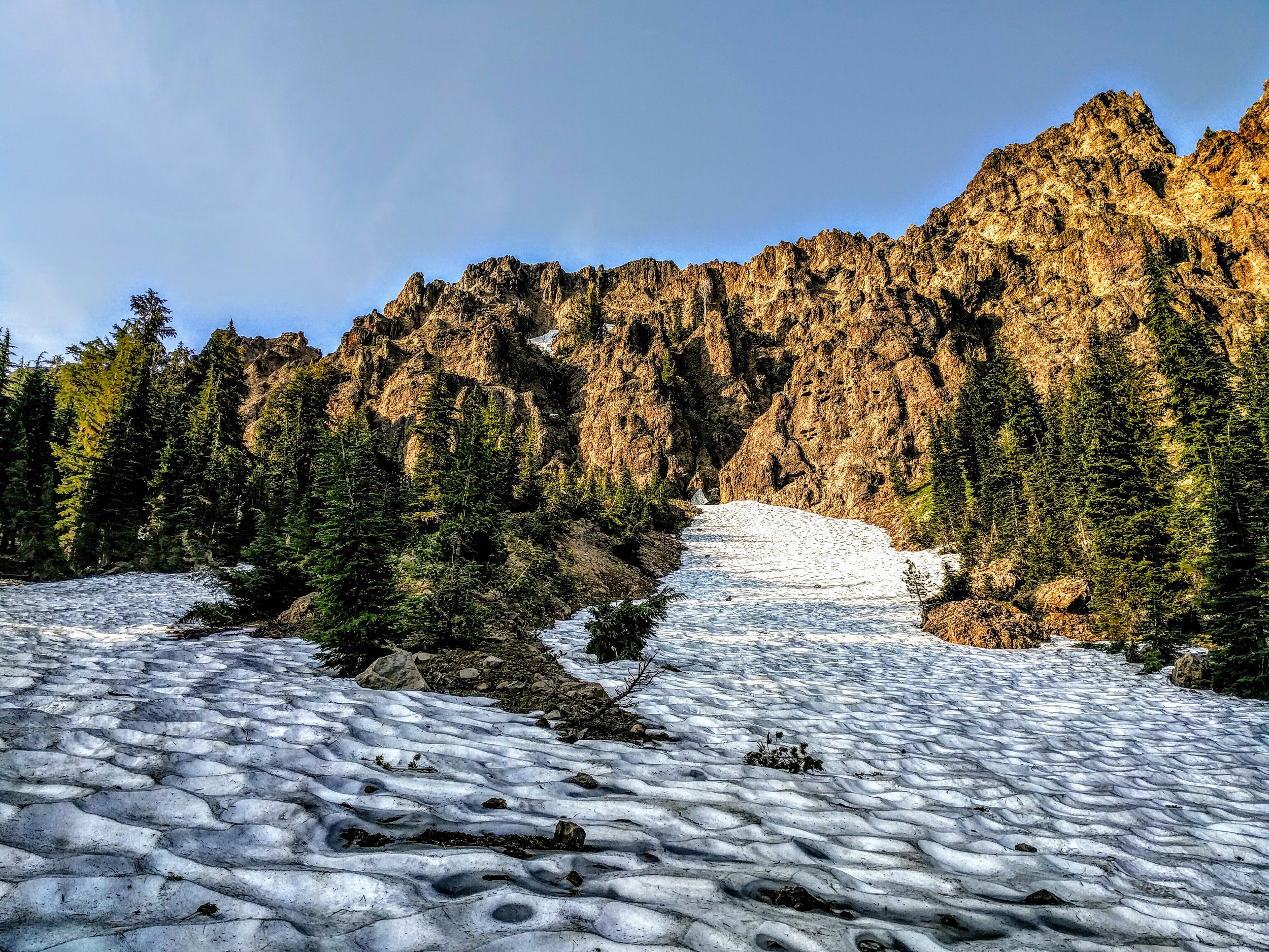
Highland Peak stands at a lofty 11,000-feet in the Sierra Peaks Section of California
The night before I had made sure to pack the necessary gears for peak bagging:
A liter of water in my CamelBak Arete hydration pack
Peanut butter sandwich, Clif bars, Justin’s almond butter
A long sleeve top and a light jacket for windy conditions at the summit
A small Swiss Army knife in case I needed to cut or untangle something in the woods
A thought flashed through my mind as I was packing my gears that night - did I have everything I needed? What if there was an emergency situation and I would be lost or stuck in the mountain? Did I have the necessary equipments to survive? I brushed that thought aside and went to bed.
Back to the morning of August 5th.
0730 hours, elevation 8,300 feet
We arrived at the trail start. Hit the restroom, buckled up our day packs, and off we went on the trail. Steve had downloaded an offline map of the route to the summit of Highland Peak onto his phone. Steve is a seasoned and veteran peak bagger - he started climbing mountains in 1995, and between then to-date, has climbed 130 of the 247 Sierra Peaks Section and all 15 14ers (mountains above 14,000 feet) in California. He has climbed Mt Whitney, the highest peak in all 48 contiguous United States, 8 times. That is quite an accomplishment! I felt safe peak bagging with him, and didn’t think of carrying a map myself. I would just stick real close to him.

Steve is fit as a mule and has an impressive repertoire of mountain climbing experience under his belt
1100 hours, elevation 10,400 feet
In the past 3.5 hours, we had hiked 5.5 miles. A slow progress, but fair given we had to cross a number of creeks, tread gingerly on several sections of slippery snow and scramble up loose rocks and boulders. Well, to be honest, I slowed Steve down. He was fit; I wasn’t. He had to stop and wait for me to catch up from time to time. At 10,400 feet, I was too exhausted to carry on. The 11,000-feet summit loomed in the high horizon. Just 600 feet to go!
Even at the height of summer in August, snow is visible in the high mountains
Up to that point, gone was my ambition to summit as quickly as possible; instead, survival mode kicked in - I was intent on keeping safe and watching my footing so that I could make it to the summit and back. My vision turned from macro to myopic - from the expansive snow-capped mountain range to simply about putting one foot in front of the other.
I'm never one to give up but I hate inconveniencing others. I was slowing Steve down too much. I told him to go ahead and bag the summit (it was his quest anyway that I was tagging along). He did, and promised to come back as soon as he could. I gave him the thumbs up, and watched him disappear up the rocks. I slowly made my way as far up as I could, found a flat piece of boulder to sit on, and rested. I peeled open another Clif bar, enjoyed the serenity and solitude of high elevation, and realized: my God created all of this that I see - this majestic mountain range surrounding me, the very one I'm sitting on, and should I stumble and fall, I'd fall into His very creation, into His very palm. At that point, I felt utterly safe, cradled, and loved.
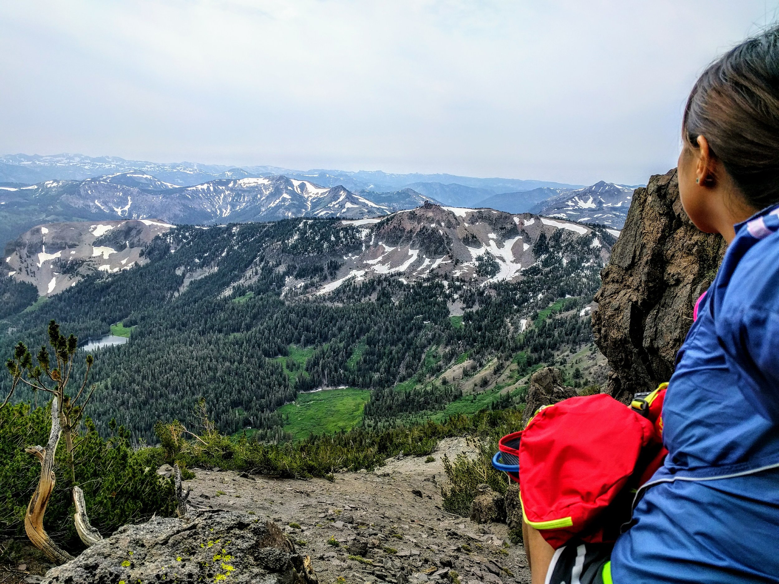
View from elevation 10,400 feet. Enjoying the solitude and serenity of high elevation, basking in God's love and assurance
1215 hours, elevation 10,400 feet
Rested and recharged and feeling a little chilly (it’s usually windy at mountain tops), I started making my way down the mountain. I was slower than Steve; if I had a head start, he would quickly catch up to me.
1230 hours, elevation 10,300 feet
It’s been an hour and a half since Steve and I parted ways. It was a mere 600 feet to the summit from where we parted ways. He should have submitted the peak and made his way back by now. I kept turning around to look out for Steve. No sign of him.
Steve! I shouted.
Silence.
Steve!
Silence.
Hello?
Silence.
I was starting to worry. Did something happened to him?
I kept shouting his name. I heard my voice echo through the mountain.
I continued slowly down the mountain, turning back ever so often to look out for him.
1245 hours, elevation 10,200 feet
I saw a silhouette appear from behind the high rocks: first the head, then the body, and finally, a full body. I waved frantically. He waved both hands. It was Steve!
Relieved, I waved some more, and gestured for him to descend the mountain to where I was.
Steve’s come back for me, I told myself. I smiled, sat down where I was, took my shoes off and dusted off the loose rocks that gathered in my shoes. Steve would be here soon.

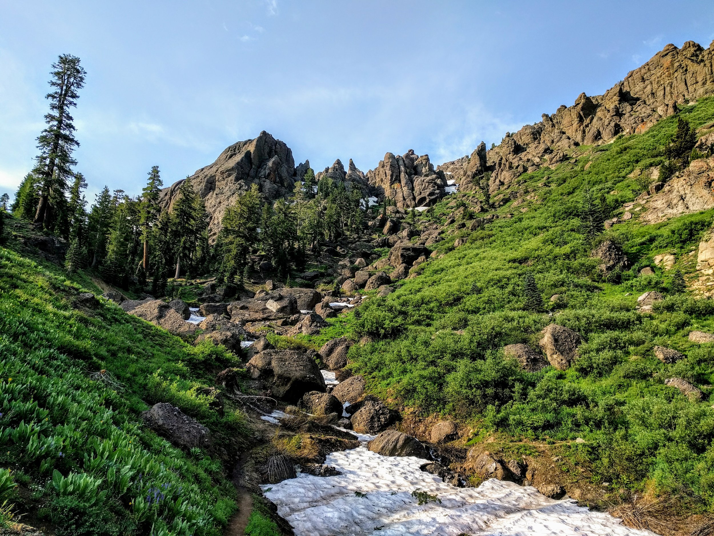
Scrambling down the mountain on loose rocks and boulders
1255 hours, elevation 10,200 feet
10 minutes went by. No sign of Steve.
Strange. He should have been here by now. He wasn’t that far off when we last waved to each other.
Steve?
Steve!
Several minutes of silence went by.
Steve! I screamed louder, using a higher pitch so it would echo farther.
Then I heard a voice: Angie!
Steve! I shouted in response.
I looked to where the voice came from, squinted my eyes, and identified Steve by his blue shirt in between the trees.
Steve! I’m here!
Relieved yet again, I waited for him to appear.
1305 hours, elevation 10,200 feet
Another 10 minutes went by.
Steve was nowhere to be seen.
No, not again. What happened? Did he pass me by?
Steve! I shouted again and again.
1315 hours, elevation 10,100 feet
I was getting desperate. How did we miss each other when we obviously heard each other and I saw him briefly in between the trees.
Steve, where are you? I’m here.
Did something happen to Steve? Did he fall and break his ankle?
Time was ticking. If Steve was really in trouble, I had to do something.
I tried to climb up the mountain to where I last saw him, shouting his name from time to time, hoping to give him an idea of where I was.
Failing to find him, I made my way down the mountain again. I had to get help before it got dark.
1325 hours, elevation 10,000 feet
Steve, where are you?
A bird crowed in the distance.
My heart was racing. No, this isn’t happening. This is not real. This must be a trick. We heard each other. We were almost united. Surely we would find each other.
Steve! I screamed at the top of my lungs. Steve! Steve!

This section of mountain range is remote: the last time someone climbed up Highland Peak was two weeks ago. As far as the eye could see, there wasn't another soul to be had in the mountain yonder and the valley below.
1330 hours, elevation 9,900 feet
The wind blew a cold air. I shivered.
An image flashed through my mind: Nightfall. I’m alone and lost in the mountain without warm clothing. No food, no fire, no rescue.
No, I brushed away that image. This isn’t how my life would end. Devil, no, not today, I declared.
Perhaps Steve fell into a ravine, I reasoned.
Steve, are you alright?
Silence.
Steve!
Then...
Angie!
Steve! Hey Steve, I’m here! Where are you?
I ran towards the voice.
I saw no one. Just rocks and trees.
Steve!
1335 hours, elevation 9,800 feet
I ran up and down the mountain several times, in several directions.
What is going on? How is it that I could hear him, and he obviously could hear me, but we could not find each other?
Should I wait for Steve to find me? Should I make my way down the mountain into the woods?
But I don’t know which way to go. I had no map. I didn’t know where we parked the car and where the trail start was. I had no idea which route we took. I was clueless and utterly hopeless.
At that point, a bleak realization hit me: There’s a high possibility I would be stuck here all by myself if Steve and I couldn’t find each other.
I was petrified. I scanned the valley below. As far as I could see, there wasn’t another soul out there.
I looked up. No airplane and no helicopter in sight. If I were to be stranded, I would have no help.
Then I remembered passing by a lake on our way up, looked down the mountain and saw two lakes. I didn’t know which lake it was we passed. I guessed it was the one closest to me so I ran down the mountain towards it.
In between running down the mountain, I’d stop, shout for Steve, and run some more.
1340 hours, elevation 9,700 feet
I stopped running. I had no idea where I was headed towards. Steve hadn’t responded.
I made a desperate plea to God: You created all of this that I see. There is nothing to be afraid of. You are with me.
I ran down the mountain some more. I came to a huge fallen tree and rested on its thick trunk.
I’m afraid... I said to the birds above me.
Somebody help… I cried weakly.
So this is how my life would end, I thought.
Angie!
Steve? Steve! I’m here!
I waited. My heart raced. Please, let Steve appear this time. Please.
Finally, Steve appeared.
1345 hours, elevation 9,600 feet
Are you alright? Steve asked.
Yes I am. I’m so glad to see you!
Are you really alright? He asked again.
Yes, I’m ok. I’m just relieved to see you. Let’s talk about what happened later.
We had lost time on the mountain. I was anxious for us to continue our trek down the mountain. We scrambled over rocks, across fields, wild flowers, narrow paths, rushing creeks, snow slides, open meadows, and finally, we saw other human beings. Hikers along the Pacific Crest Trail.
We hiked down the mountain into the green valley and eventually, civilization
1715 hours, elevation 8,300 feet
We arrived at the trail start. A large group of four families with dads, moms and children, each carrying fully stuffed backpacks, were preparing to hike to a nearby lake to camp overnight.
Will you take a group photo for us? A woman amongst them asked.
Sure, I said.
Oh, one of us is in the restroom. If you would wait a minute or so, he should be out soon.
Not a problem. I didn’t tell her this, but I’ve got all the time in the world. After that close encounter of possibly never seeing another human being just a couple of hours earlier when Steve and I got separated, I would now do anything for another human being.
What did I learn from this close encounter?
Every person has to be prepared and responsible for his/her own safety.
1. Always carry a map and a compass and know the general direction where the car is parked.
Map - download an offline map on your phone, and if possible, carry a physical paper map in case your phone runs out of battery
Compass - download a compass app on your phone, and if possible, bring a physical, reliable compass
Know the general direction where the car is parked - is it parked NSEW of the summit?
I didn’t carry a map with me because I knew I was with an experienced hiker and I assumed that we would never be separated. I later learned from Steve after he summitted and signed the register at the summit that the last person to summit before this was two weeks ago, on July 20. What this meant was, if I had indeed been stranded on the mountain by myself, assuming Steve and I never reunited or either one of us was in serious trouble, we would have been without help for possibly two weeks before we would see the next person, or until rescue came.
2. Don’t assume anything. When separating from a group, always ask for estimated time of return. When I told Steve to go ahead and summit without me, I didn’t ask him how long did he expect to be gone. I assumed that he would take an hour to summit and return to where I was; the fact was, he took two hours. I got worried and started to descend the mountain too soon, thus widening the gap between us.
3. Don’t overreact. Stay put at the agreed location. Moving away from our agreed location would make it difficult for to relocate each other, especially in the mountains where visibility isn’t great due to the dense presence of rocks, trees and shrubs.
4. Sounds bounce off the mountain. When I heard Steve calling my name, it sounded like he was on my left, which I ran towards. Later on, I would find out that he was to my right. His voice bounced off the mountain and that confused me as to his whereabouts. It made it difficult to determine his true location. To ensure that a fellow hiker and I would always be able to communicate with each other in the absence of cell phone coverage, I researched and found GoTenna, an off-the-grid antenna hardware which allows for text messages and GPS coordinates between fellow participants. What this means is, if Steve and I each carried a GoTenna and connected it to our phones, even if we had no cell phone signal in the mountains, as was the case last week, we would still have been able to communicate via text messages and send our GPS coordinates (on downloadable offline maps) to each other. I had just purchased GoTenna and will be using it in upcoming peak bagging trips. I will post detailed reviews on the product then.
In the meantime, I hope this post cautions you of the dangers of unpreparedness and gives you helpful information on ways to stay safe and connected in the great outdoors. It’s a beautiful world we live in - go out and explore, and do so safely. ;)
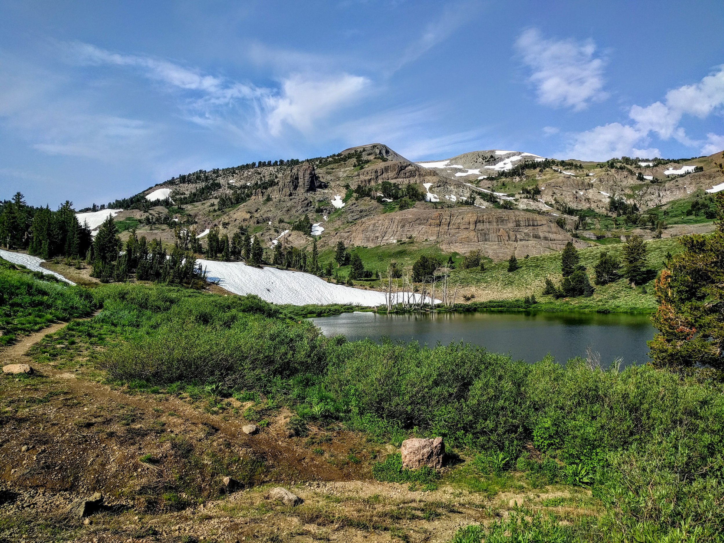
Noble Lake located along the Pacific Crest Trail leading up to Highland Peak